Friday, July 31, 2020

July 31: Ride to Presho, and time for swimming


She is called Dignity

Today, I rode to Presho, after two rest days in Chamberlain. I did quite a bit of sightseeing on my rest days, and most of the photos on this page were taken there.  The first place I wanted to check out was St. Joseph’s Indian School.  Along with Boystown in Omaha, SJIS  was one of my top goals to see while on this trip. Included on the campus is a very nice museum dedicated to the Lakota Sioux. I spent a couple hours there going through the exhibits which described the lifestyle of the Lakota Sioux in the early 1800’s when Lewis & Clark made their expedition of discovery. The Indians were totally dependent upon the buffalo, and the plains in this area were home to thousands of them. I have not yet seen any.  Eventually almost all of their land was claimed by the US government, and the Indians were moved from place to place, a very sad story. Another interesting place on the campus is the chapel where the children attend Mass. While there I met a husband and wife. The wife attended SJIS around 1960.

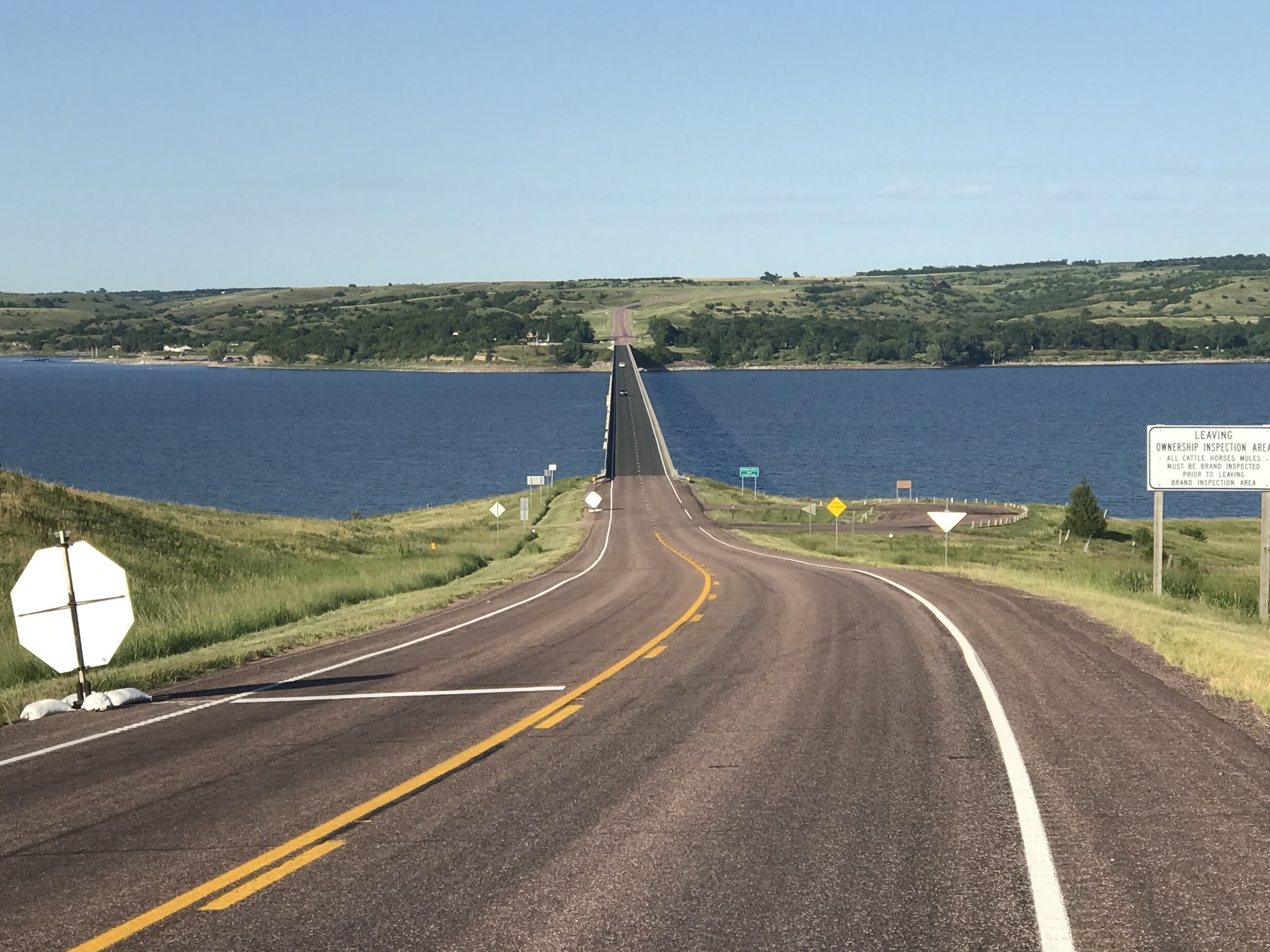
My other tourist highlight is the Lewis & Clark Interpretive Center which is part of a rest area on Interstate 90. The area is dominated by the statue named Dignity which is shone above. You can get an idea of the size of the statue, when you compare the size of people,  on the extreme left edge of the photo. Inside the rest area building is another nice museum which depicts the life of the members on the expedition. Very interesting, and I spent two hours here as well.

After a couple rest days, my body was ready to resume the ride, so today I left Chamberlain, and headed west along the Interstate to Presho. Technically Presho is not on the Lewis & Clark route. Instead of west I should have traveled north out of Chamberlain. However, I was advised that due to Covid, the Indian Reservations are locked down, and outsiders, like me, are not being permitted to travel though them. Bikes are allowed on interstate highways in SD, and I did ride on I-90 for 9 miles today. The rest of the ride was along a frontage Highway  very close to I-90, and I had the road mostly to myself. Except ironically, wide load semis weren’t permitted on I-90, so those trucks had to use my road. 

Compared to previous days, the ride was pleasantly uneventful. I did notice that now new crops were showing up in the fields, including wheat, sunflowers and sorghum. I got  a much better picture of sunflowers today. I arrived in Presho before 2:00PM, so I as able to avoid the worst of the heat. Presho is small, and only has one paved street which is Main St. All the rest are dirt roads. The temps got up to 91 again but I beat the heat by taking a swim in the local city pool. Impressive facility for a town that does not have paved streets. The deep end is 12 feet deep and has both low and high diving boards. My swim session was cut short due to an impending storm, and just like in the 1960’s in Medford, we were whistled out of the pool at the first rumble of thunder.

Tomorrow I will continue my ride to Pierre, using the route suggested by  a couple officers of the SD state patrol who happened to be having supper at the same Dairy Queen restaurant as me.


  Our Lady of the Sioux Chapel

                                     Statue at the entrance to St. Joseph Indian School

Along the waterfront in Chamberlain

City park in Chamberlain

View of Chamberlain from Interstate rest area

Lake Francis Case (Missouri River) -  view from rest area

City of Chamberlain 

100 00.00 degrees West Longitude - no marker


My swimming cut short by threatening weather - notice high diving board

Great swimming pool for such a small town

A picture of a field of sunflowers for Mom

Patchwork of crops - sorghum and soy beans left of road and wheat to the right

My guess they are headed to Sturgis one week early


Museum at visitor center
 5 or 6 guys would sleep in that tent

 Full length keelboat display

  A first for my bike - a stop at an interstate highway rest area

Aug.1: Fort Pierre National Grassland: tough wind on the ride to Pierre


Presho Pool 

After receiving about a half inch of rain throughout the night, I am really happy I chose the cabin instead of the tent at the KOA campground. I actually picked up a little mud on the bike and shoes while riding back to the campground last night. There has been very little rain during my journey. 

Today I rejoice with a forecast high only in the 70’s. My destination is Pierre, and my route will consist of 14 miles westerly travel next to I-90 on a frontage highway followed by a right turn on US 83, and 30 miles of northward travel through the Fort Pierre National Grassland.  Readers may have noticed that I am now recording both northward travel and westward travel in my stats. Westward travel has predominated, since the Elk Point campsite. Today that changes, as for the next few weeks, it is northward, always near US 83, and little westward progress.  For me, north has always been my direction of choice, trying to flee the brutal summer heat and humidity of our nation’s midsection.  So north is the direction I am happy To take now, until northern ND where the Missouri River makes its final turn to the west.

After leaving Presho, my first and only stop of the day is the Sinclair gas station on the US 83 exit. It’s a very busy place, with a clientele mixed with Harley riders and large RVs. Some pickup trucks hauling trailers with RVs.  I am the only bicyclist.  Matter of fact I haven’t seen any other bicyclists at all in South Dakota that I can recall. The annual Sturgis motor cycle rally begins in a week, and my guess is that is the destination of most of the cycle riders. 

Now I strike out onto a Highway 83, with Fort Pierre 30 miles to the north, and nothing in between. I haven’t had a strong headwind in a long time, but today I face a 15 mph wind from the north to northeast. The rolling grassland puts up no barriers to block it, so all I can do is gear down, and  work into it. 
I suspect the cooler temperatures and the north wind are related, and for today at least, I am fine with the headwind. The Fort Pierre National Grassland is 116,000  acres of wide open prairie.  Views extend to the horizon in all directions.  South Dakota’s version of a Big Sky Country, I would call it. I take a break, every hour or so, and five hours later I pull into a Fort Pierre.  A good day.

Miles:  Total 46.2.   North progress: 32.2. West progress: 16.0
Elevations:  Max 2175 (new high point)  Min. 1425 at Fort Pierre
Max speed:  24.3 mph


The start of my northward trek on US 83.
                                      Entering the National Grassland an hour later

Taken another hour later. A great deal of sameness. Desolate.

Finally starting the big downhill into Fort Pierre and Missouri River valley.

                                The Bad River flows into the Missouri at Fort Pierre

                            End of day: back on the Missouri River, at Fort Pierre. So blue!

                                                   Having fun on the Missouri at Pierre


Thursday, July 30, 2020

July 28: Tom, A Good Samaritan helps me get to Chamberlain


Prairie Skies Country Inn  saves my day

It was very bad news to find the restaurant and convenience store closed at the Snake Creek Camoground. I’ve been relying on my cycling map to provide information about services along the route. Snake Creek provides the only services between Bonesteel and Chamberlain, a distance of around 80 miles.  With the campground restaurant closed on Monday and Tuesday, not only did this mean no supper on Monday night at the campground, but also no food for the ride on Tuesday until my destination 48 miles later.  My food for Tuesday would be some snacks, namely a package of licorice and a bag of peanuts.  My water situation was worse. I had tossed a couple of empty bottles into the garbage yesterday. There was water at the campground, all that I could carry. But I only had two liter size bottles, while normally I was consuming four bottles in a day.  

So I broke down my campsite, and I drank about two liters of water before leaving hoping that could help for the upcoming ride.  Sort of like carbo loading, but I don’t know if that works for “water loading”.  The route to Chamberlain didn’t Seem to challenging. There was a long uphill pull of 300 feet of elevation or so to start the day as I pull myself out of the river valley, but then after that, the route was all on highways and no serious hills.  However, I began to realize it was going to be tough, as I was already sweating heavily on that initial pull. The temp was higher than it should’ve been compared to the forecast, and not a breath of a breeze.
 
I had figured out that I could have four pieces of licorice for every ten miles traveled, and lunch would be the peanuts. So around ten miles into the ride, I had just had my ration of licorice when I came upon the sign in the photo above.  The cycling map did not mention the Prairie Skies Country Inn. It was  3.5 miles off route, but I thought there was a good chance I could get food and water there. But what if the place was closed or no longer in business? It would be 6 extra miles for no benefit.  So technology to the rescue. I thought there might be a website, and if so maybe a phone number for the place. While I had terrible luck yesterday with the closed restaurant, my luck turned favorably now. Luckily I had cell coverage, and luckily a website provided a phone number.  And luckily, Tom, the owner of the inn answered my call.  I told him about my predicament, especially my need for more water. Tom asked my location, and agreed to bring me some bottles of water; I didn’t even have to ride to the inn, as he was willing to deliver the water bottles to me!  He showed up a few minutes later with the water he promised but also enough food to last me for the rest of the ride.  He brought a couple ham sandwiches, some nuts, a chocolate chip muffin, and three pieces of fruit.  He brought me exactly what I needed to get through the day.  And he would not take any payment. 

 When he found our I was from Wisconsin, he proceeded to tell me the story about his 11 year old daughter, who became gravely ill, while performing on an honors choir tour to Wisconsin. She was originally mis-diagnosed, and when finally the doctors understood the severity of  her situation, the doctors basically provided no chance for recovery. In fact his daughter did recover, in a manner which could only be explained as being a miracle, actually a series of miracles. His daughter is now 13 and has lost her legs due to amputation, but now looks forward to a rewarding life.  We talked about “paying it forward”,  and I only hope to have a similar opportunity sometime in the future to pay it forward.

It is amazing that Tom seemed to know exactly what I needed to make it through the rest of the day. But it was by no means an easy ride for the rest of the day. It was a very difficult ride, as I had to ride through the heat of the afternoon, with no breeze, and almost no shade available.  I took several breaks, whenever I could find some shade, and one of my breaks was in the broad daylight. Finally I got to a little town named Pukwana. Tom had mentioned a place to get food there, and he was right. The cycling map didn’t know about it.  I was so thirsty for something that wasn’t water, and I drank three cans of Coke. I ordered some food, and my meal was paid for by a couple of the local patrons. An amazing day.

Now somewhat refreshed, I finished the remaining 10 miles to Chamberlain; slowly but without further incident.  Exhausted by the ordeal of the day, I decided a couple rest days were in order in Chamberlain. As for the situation at the campground, I will be writing to Adventure Cycling letting them know that the campground restaurant is now closed on Mondays and a Tuesday’s, and that cyclists needing food should plan to reroute if they are going to have a Monday or Tuesday arrival.   The toughest rides of the trip so far have been on a Monday’s when  places noted on the cycling map have been closed.  I am going to consider making Monday’s a rest day, if I am in an area with few services, which unfortunately describes most of the rest of the trip.  Also I will plan to carry emergency food, in case something like this happens again. Live and learn.

Miles: 53
Elevations: High: 1825: Min 1410
Max speed:  23.6 mph
North Component: 51 miles (2 days)
West Component:  41 miles ( 2 days)

One and only field of sunflowers so far


Snake Creek campground
                                                           My campsite. But no food to be had

July 27: Shortcut on Old 1806 road to Snake Creek Camoground


 Shortcut Road, Old 1806

I was psyched up today for the ride, after a good performance yesterday.  Today’s route was going to be challenging, since it was going to be over 60 miles and it included 15  miles of dirt road in questionable condition.  But I figured I could go hard today, and set me up for an easier day tomorrow. Or so I thought.

So the day started with a couple of views of Lake Francis Case, which is the name of the river in this region. Lake Francis Case is formed by the Fort Randall Dam, which is nearby but not on my route. The lake is 100 miles long, so I would be seeing Lake Francis Case for several days. I have no idea who Francis Case is/was. 

So after crossing the lake my next couple hours of travel was along US 18 - yup, same one that runs on the Madison beltline - which took me to the small town of Bonesteel.  Some new crops have begun to show up, with fields of harvested wheat, I think, with the big circular bales. Or maybe just hay fields, I’m not much of  a farmer!  Also I saw the first  of the innumerable Wall Drug billboards.  I was going to skip the photo, but decided to snap a shot when the second one showed up a few miles later.  Wall is 200 miles away and not even on this highway. So I’ll start counting the billboards now, haha.  At Bonesteel I had the luncheon special at the Tee Pee Cafe, which was the first meal I’ve had at a real cafe in several days. Most people around here rely on their local bar and grill, if they want to go out to eat.  The population around here is so low that I guess it’s hard to make a go of it, by only serving food.

At Bonesteel, the cycling map provides two routes. The main route which I would guess is the route most cyclists take, follows along regular highways. However, the second choice is ten miles shorter and travels on Old 1806. This shortcut has 15 miles of dirt roads, and some crazy steep hills. I love shortcuts, and I have bike tires that are suitable for dirt roads, so I selected the shortcut route. Also, this route followed the river closely so I also was hoping for some river views.

I am happy I took the shortcut.  First there was an amazing descent in which I dropped about 500 feet and registered a max speed of 42.5 mph, fastest of the vacation so far. This was on a paved road, of course. Then the dirt road which climbed  back up the hill I had just descended.  The road was in decent shape, with only a little washboarding. Some nasty biting flies, but not bad. There were three hills that I had to dismount and push the bike up. But certainly worth the ten miles I was saving. And as a bonus, I got some nice views of the river from 600 feet above.  Second bonus: this road topped out at 2089 feet, so I broke through the 2000 foot mark, and got a new max elevation.

Eventually, I joined the main route, which descended back down to the river (still really Lake Francis Case), that I crossed again back to the  east side, and stopped at the Snake Creek Campground, my home for the night.  It’s a beautiful campground, right on the water, a great spot, except for one very serious shortcoming. The cycling map indicates a restaurant and a convenience store at the campground. But when I went to the restaurant, I had misgivings, there were no cars around.  I got to the door, and saw the sign: closed on Mondays and Tuesdays. Today is Monday. Uh oh.

Miles: 62
Elevations: Max 2089 on Old  1806.  Min 1392, on Francis Case bridge
Max Speed: 42.5 mph


                                                         Lake Francis Case (Missouri River)
Lake Francis Case
                                                            One more view of the lake
                                                                  Is this a wheat field?
Wall Drug is 200 miles away
                                                   At the top of my shortcut. 42.5 mph
                                                              View from the top 
 
                                                           Narrow bridge over the lake
                                                    View of 5he river from 600 feet up
                                           Water is beautiful shade of blue: time for swimming!   
                                                This is actually the bridge back to the east side 

Sunday, July 26, 2020

July 26: Pickstown and the Yangton Sioux Reservation


Lake Francis Case at sunset

You know it’s a small town when the lady who waited on you at the local tavern is the same person who checks out your groceries at the food store the following day. After waiting for two days in  tiny Springfield for the temps to recede from daily highs in the 90’s, Mother Nature decided to cooperate with a high of 83 today (Sunday), and it was good to get back on the trail of Lewis & Clark. My route today skirted the Missouri River along the Native American National Byway, through the Yankton Indian Reservation.   So I bade goodbye to Mark and Theresa at the Springfield Inn.

I had a choice of routes today. I could follow the regular route to Pickstown utilizing SD highways, or I could follow the scenic route  suggested by the cycling map through the reservation. I am happy I chose the scenic route. Actually here were only a few views of the river prior to the end of the ride at Pickstown, but the scenery with the bluffs from both sides of the river was pretty. The challenge of today’s ride was that there were no services along the entire route of 47 miles. When I arrived at the small town of Marty, I stopped to rest and ate the food I had brought along for lunch. Carrying a meal is no problem, when I know in advance that there are no services. Things get  ‘interesting’ when a store that bike travelers depend upon for food is closed.   Stay tuned!

This turned out to be an easy day of riding, after a couple rest days. I’ve heard that the most Important days for the body in training are the rest days.  Definitely true for me.  There was some rain in the forecast which was expected to hit before the end of the ride. No worries. The clouds broke up and  I had sunshine by the end of the ride, as you can see in the picture below.

Geographics: Two items of note today: I pushed my max elevation for the entire trip up to 1850 feet today north of Marty. I’m looking forward to pushing through  the 2000 feet level soon! Also after flirting with 
 A latitude measurement of close to 43 degrees for the last couple days, I finally achieved it today. My apartment in McFarland is exactly at 43 degrees north latitude, so I am for the first time further north than McFarland. And that is where I will stay for the rest of the trip, Yay!

Miles: 47
Elevations: Max: 1850  near Marty  Min:1233 At start
Max speed: 30.2 mph


Note: The order in which the photos appear when I enter them often doesn’t always follow correctly in sequence. For readers who are trying to follow me through the day sequentially, proceed through these photos backwards from last to ftrst.
 
                                                   End of ride today at Lake Francis Case
Sweet downhill toward Pickstown
Tipi on Yankton Sioux Reservation
Missouri River
Threatening skies over black walnut - but no rain
Home for two days - the Springfield Inn
                                                Channels of the river at Springfield


August 11: Parshall and New Town

Van Hook Bay of Lake Sakakawea near New Town A familiar foe showed up on day 4 - a tough headwind.  Generally, this year I found the cycling...