
Presho Pool
After receiving about a half inch of rain throughout the night, I am really happy I chose the cabin instead of the tent at the KOA campground. I actually picked up a little mud on the bike and shoes while riding back to the campground last night. There has been very little rain during my journey.
Today I rejoice with a forecast high only in the 70’s. My destination is Pierre, and my route will consist of 14 miles westerly travel next to I-90 on a frontage highway followed by a right turn on US 83, and 30 miles of northward travel through the Fort Pierre National Grassland. Readers may have noticed that I am now recording both northward travel and westward travel in my stats. Westward travel has predominated, since the Elk Point campsite. Today that changes, as for the next few weeks, it is northward, always near US 83, and little westward progress. For me, north has always been my direction of choice, trying to flee the brutal summer heat and humidity of our nation’s midsection. So north is the direction I am happy To take now, until northern ND where the Missouri River makes its final turn to the west.
After leaving Presho, my first and only stop of the day is the Sinclair gas station on the US 83 exit. It’s a very busy place, with a clientele mixed with Harley riders and large RVs. Some pickup trucks hauling trailers with RVs. I am the only bicyclist. Matter of fact I haven’t seen any other bicyclists at all in South Dakota that I can recall. The annual Sturgis motor cycle rally begins in a week, and my guess is that is the destination of most of the cycle riders.
Now I strike out onto a Highway 83, with Fort Pierre 30 miles to the north, and nothing in between. I haven’t had a strong headwind in a long time, but today I face a 15 mph wind from the north to northeast. The rolling grassland puts up no barriers to block it, so all I can do is gear down, and work into it.
I suspect the cooler temperatures and the north wind are related, and for today at least, I am fine with the headwind. The Fort Pierre National Grassland is 116,000 acres of wide open prairie. Views extend to the horizon in all directions. South Dakota’s version of a Big Sky Country, I would call it. I take a break, every hour or so, and five hours later I pull into a Fort Pierre. A good day.
Miles: Total 46.2. North progress: 32.2. West progress: 16.0
Elevations: Max 2175 (new high point) Min. 1425 at Fort Pierre
Max speed: 24.3 mph

The start of my northward trek on US 83.


Taken another hour later. A great deal of sameness. Desolate.

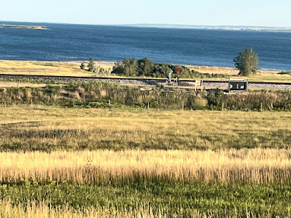
Finally starting the big downhill into Fort Pierre and Missouri River valley.


Yes, folks on their way to Sturgis. Saw a FB post that someone I used to work with made it there. Am asking others to post a comment or two so I am not the only one... I'm sure he'd appreciate hearing from you. If the Comment as: doesn't know who you are, identify yourself in the post.
ReplyDeleteThis way Mark can also see we are following his journey. Thanks!!