Saturday, August 29, 2020

August 9: Headwinds on long ride to Bismarck


Believe it or not, this is the North Dakota Capitol building


After a rest day, and finally a good night of sleep at Don’s Motel at Linton, ND I was ready for a long pull today to Bismarck.  My route was a simple one, 41 miles north along US 83, followed by 21 miles west to Bismarck.  No towns along the way, in true ND fashion.  A nice cool morning to start, the first twenty miles were uneventful. I just wish I had gotten an earlier start, and got more miles down the road, because suddenly at around 10:00AM the winds began. Winds which did not letup for the rest of the day, from the northwest, at 22 mph. This was just bad luck; wind from the north or wind from the west would’ve been ok. Northwest meant no break for 40 some miles.  The wind would gust up to like 30 mph in some places. This was the toughest wind day of the entire vacation. The next day, the wind reversed and came out of the east which would’ve been an awesome tail wind. I guess I just got to Bismarck one day too early.  

Along the way on Highway 83 I passed an unusual sign which turned out to be a memorial for five men who died in a car accident. I looked up a news clipping on the internet; the story is that the accident happened about 2:00AM. Two cars had a head on collision. One car with three occupants were carpooling home after the night shift from their jobs in Bismarck. The driver of the other car crossed over the centerline causing the crash. It was a reminder to me that it is vitally important to remain conscientious about safety at all times, and that it is late in the day that mistakes are most likely to happen when the brain is tired. 

Eventually, I did reach Interstate 94, the same road near my place in McFarland. I had two options for the last 21 miles to the west to Bismarck. One was a frontage highway which parallels I-94, the type of road I’ve taken to good advantage in other places on the trip. The alternative was 2 miles further, right on the shoulder of I-94.  Some of the western states permit bicycles on the Interstates, riding along the shoulder of course. This decision may seem to be a no brained, to take the frontage Highway, Actually I took the Interstate, even though it was longer. Can you figure out why?

My average speed along Highway 83 was around 6 miles per hour.  It takes a good long time to travel anywhere at that speed!  Along the frontage road, Bismarck was still three and a half hours away. The advantage of the Interstate was the drafting effect I would get when semis and large RVs pass by. 
My gamble paid off: the drafting improved my speed to about 8 mph.  I got to Bismarck about 45 minutes earlier than along the frontage road.  So math to the rescue! 

Miles: 62
Average speed: 7.2 mph
Max speed: 16.7 mph


                                     Rural US 83, traveling northward in Nort Dakota
             Cows were fairly uncommon; this herd stopped to look at me so I took their picture


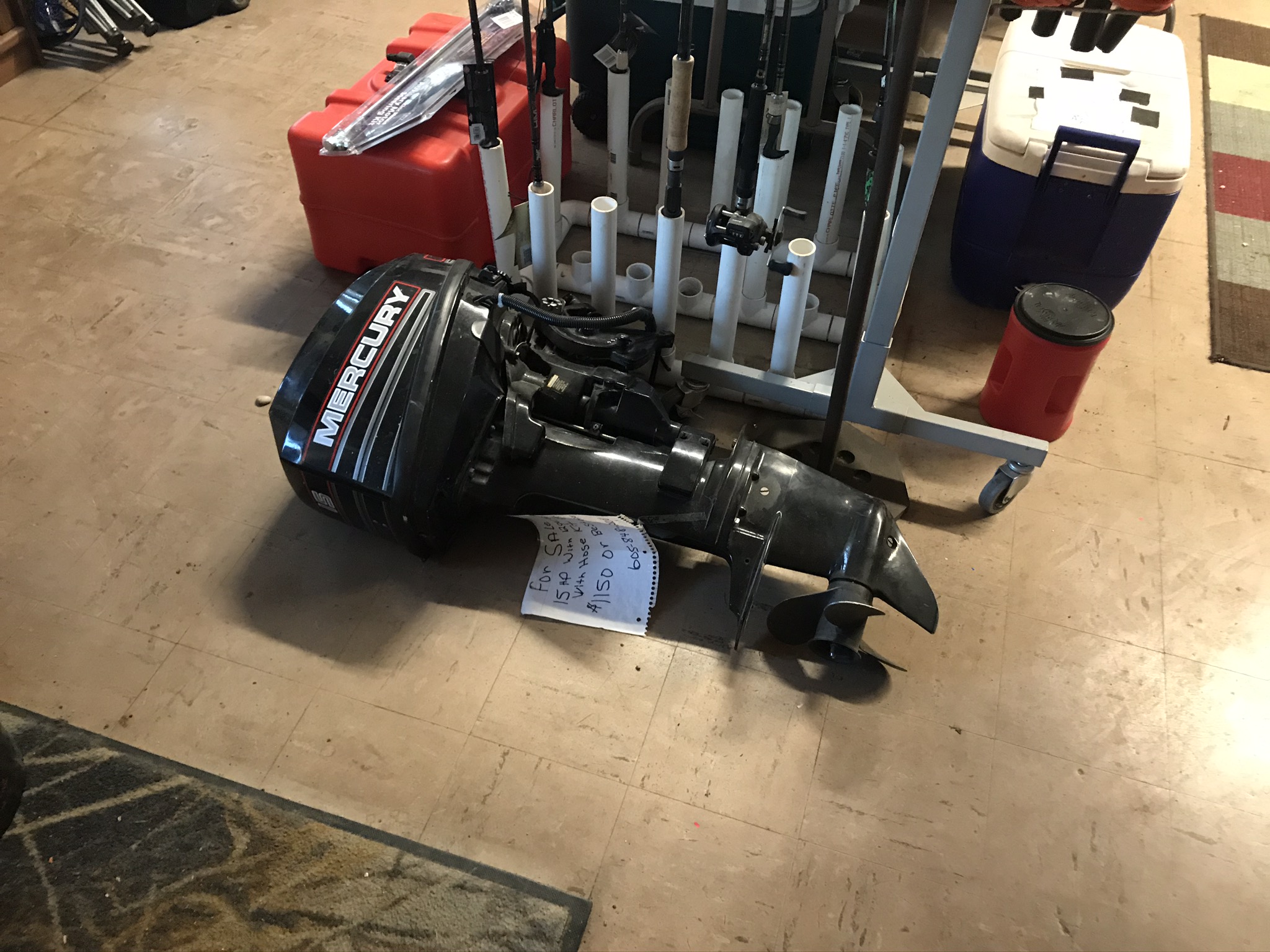
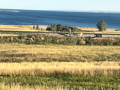
Look closely: this was a welcome sight

Saturday, August 15, 2020

August 7: Route 1804: A bit too “Lewis & Clark” for me


                                             Lawrence Welk grew up near Strasburg, ND

So last time I posted my experience for lodging in Pollock, South Dakota. Pollock is the last town, actually the last of anything in SD. Talking with some of the locals, my concerns were confirmed: between Pollock and Bismarck ND, along Highway 1804 - my route on the bike mapI s- there are no services at all. This is a ride of two days.  Which meant carrying food and water on the bike, enough for two days.  And of course, if I have a bike breakdown, well who knows??  When this vacation started I remembered thinking it would be fun to somewhat relive in a modern fashion, the L & C experience. Meaning being self sufficient for food and other necessities.  However at this point, that didn’t seem fun at all! I’ve been spoiled by my lifestyle. And L & C had guns and abundant game which  provided them their meals.

It was also in Pollock that I met the only other cross country cyclist along my journey. Her name was Triva, from North Carolina, and riding across America. But neither of us realized what that entailed, in this part of the country.  The option was add twenty miles to the route, and jog east back to venerable US 83, the road which would be my companion all the way to Minot. At least there were a couple small towns on Highway 83.  That was my choice, and later I found out that Triva had made the same choice.

So another ten miles back east - seems like I’ve been doing that a lot lately on a trip with the objective of the Pacific Ocean. A benefit though was that I had a chance to visit Strasbourg, ND, which was the boyhood home of Lawrence Welk. I didn’t go to the actual residence, since it was off my route a ways, and the day was getting hot again.

The second town I visited was Linton, which is a county seat; population about 1000, so a moderately sized town by ND standards.  I opted for Don’s Motel, which turned out to be a nice place, and probably half the price of the chain hotel across the street. I found myself doing that quite often on the trip, since the cost for sleeping was my biggest expense. Don was very friendly, and gave me some important information; I decided to spend a second night there.   There was actually a heavy rainstorm in the morning, so staying there was a good idea.  The next ride was going to be a long one,  65 miles to get to Bismarck. 

Linton was a another prototype small town, like so many others on this vacation. Usually only one place available to get a meal in the evening, invariably a bar and grill place. That’s where everyone went of course. So many times, I would meet for a second time a person that I met earlier in the day, in the town.  I ended up eating a lot of fried food on the trip. All these menus seem to look the same after while. There was actually a pizza restaurant in Linton, that was my first choice. But it closed at 7:00PM on Friday’s, and didn’t even open on Saturdays.  One surprising aspect of these small towns, with populations From 500 to 1000. They all had municipal swimming pools, and they were always open.  It reminded me of my childhood, and how we would pass the summer. Keeping cool at the local pool.  It’s surprising to me how few of the towns near where I live have municipal pools. McFarland does not. Even Madison had no local outdoor pool until relatively recently. One more note: the pools in South Dakota all had high diving boards, another throwback to my youth. 

Miles: 39

North progress: 25.2 miles  West progress: negative 2.5 miles

Elevations: max: 1820;  min: 1629

Max speed: 24.8 mph

                            So many sunflowers, I didn’t know they were such an important crop.
                    North Dakota likes to let you know when you’ve crossed the state line.
           South Dakota, not so much.  My entry into SD, back near Elk Point, had no state line sign at all.

                                                                   My Covid profile.  


Thursday, August 13, 2020

August 6: My night at the fishing bait tackle and lodge in Pollock


                            Nice view of Lake Oahe between  Mobridge and  Pollock, SD

Today, I take my final ride in SD, as I travel to Pollock, the last place in SD. This makes 17 days in South Dakota;  Elk Point on day 1 seems like a dim memory. The Missouri River travels more miles in South Dakota, than any other state so far.
I greet the day by seeing fog hanging low over Lake Oahe.  The sun eventually burns off the fog, and the rest of the day my views of  Lake a Oahe are unimpeded. My route continues to be on SD 1804.  Just out of Mobridge I see  a sign on 1804 indicating the next 35 miles will have road construction.  Wonderful, that happens to correspond exactly to my mapped route!  It turns out that I never come across a work zone; the road construction was in the form of a new layer of oil. Luckily the oil must have been applied  a while ago, as the road surface was dry for the most part. 
I had great weather today, and highway 1804 provided some really scenic views. I really appreciated the contrast in color displayed before me, with the variety of crops and cloudless sky. No complaints about the road or route today. 
But the most interesting part of this day took place after the miles were finished. I arrive in Pollock around  5:00PM. There’s a grocery store, a bar and grill, and the Pollock fishing lodge. My maps indicate lodging available in Pollock, so this must be it. I enter the business and talk to the owner about a place to stay.  Sure he has a couple sleeping rooms in there that are available. I’m sure these rooms are most often used by customers who need a place to stay, before or after their guided fishing trip.  I check out a room, and it seems OK. At 6:00 PM, the owner gives me the key to the front door, and leaves for the day!  It’s me, myself and I in this place and nobody else. The place is a bit messy, to put it kindly. The guy is obviously a successful fishing guide, by taking a look at all of his plaques.  But I’m guessing the place hasnt seen a broom in a while.
Needless to say, it turns out to be one of the most unusual sleeping accommodations I’ve ever stayed in.
I get up fairly early, and load up the bike. I leave the key in the hiding place the owner indicated, and I’m on my way to my next adventure, without ever seeing.  anybody else inside the place. The following day I find out there actually is a normal motel in Pollack.

Miles: 37.4 
Northern progress:;25.1 miles: western progress: negative 7.8 miles  (I.e., I actually traveled to the East
Elevations:  Max 2101; Min. 1640; 
Max speed: 35.5 mph


                                        Fog in the morning over Lake Oahe at Mobridge


                             Turned out to be a false alarm. Did not come across a work zone

                                                      Nice contrast in colors

 Wind farm along the route

Scenic route along Lake Oahe 

Beautiful weather today

                                                   Pollock Lodge - looks kinda sketchy!
The owner must be very good at fishing - awards wall

The place is a bit junky 
This is the table from which the business arrangements as fishing guide happen
 
Anybody need an outboard motor?

Saturday, August 8, 2020

August 5: Mobridge SD


What in the world is this? And where is it?And why is my blog program now using blue font and underline?  The first two questions I can answer.  If someone knows how to turn off the blasted underline, please send me a text, or fix it!What it is: a statute titled WalleyeUp (I guess like in giddy up). It is located in Mobridge, SD.   It is made from many miscellaneous, metal pieces, just like you see with some dinosaur statues.  The statue depicts a cowboy riding a fish.  This is probably the most interesting thing in Mobridge, but I can probably find a few other items to talk about during today’s ride.So first about fishing:  fishing, especially walleye fishing is a big deal for Lake Oahe.  My accommodations on Monday, Tuesday, and tomorrow in Pollock, were all fishing guide businesses.  They say it’s some of the best walleye fishing in the world.  So if you like fishing for walleyes, now you know where to go.So speaking of Mobridge, can you guess, how the city got its name?  It came to me as I was riding along, entering the city.  If you’ve heard of Cambridge, in the UK, you’re on the right track.Today was a beautiful day with some of the best scenery of the trip.Miles:   31:  North progress  14.4miles. West progress:  15.8 milesElevations: High: 2004. Min. 1632Max speed: 27. mph

                                                      Sunset on Lake Oahe..
                 The. Road between Akaska and Mobridge: Very scenic
                                                         Sunset on Lake Oahe
                                    One more scenic view of the road to Mobridge

Friday, August 7, 2020

August 4: Gullywasher, and Math Q3

                       Threatening Skies. Maybe I should have paid some attention 

So today, my ride starts with 11 miles into some of the strongest wind of the trip, coming out of the southeast. You might be wondering why I am heading into a southeasterly wind. It’s because my route is closely following the Oahe lakeshore, and while the lake is primarily oriented north to south, the lake is very winding. Sometimes it jogs to the west.  Other times to the east. My attitude about the skies was rather cavalier as I had not encountered any severe weather at all on the ride. Very 6 littl rain, and when it rained, just showers. The picture is facing northwest so that southeast wind should blow the storm away from me, right?

Except that I don’t think wind direction really influences storm tracks. The storm was not in the weather forecast.  At least no forecast that I had seen. So I turn the corner after 11 miles and head northward - toward the storm, moving along nicely with the now favorable wind.  After a few miles it became apparent that I would be getting wet, but I did the same as the other times in ra8n and just kept riding. At last until I hard the first rumble of thunder. At that point I began to look for shelter, and there were no buildings nearby.  At first I found a large culvert that went under a side road,  and I spent about 15 minutes there.  Not a great place because I figured lightning could strike the culvert.  The storm seemed to be letting up so I emerged from my spot, and had a chance to talk with a passing motorist.  He mentioned there was more on the way and 8 saw on m6 NOAA weather app that he was right. So I decided to look for a better shelter.  Within minutes I found it, an old metal shed, out in a field, which I saw I would be able to get inside, because some wall panels were missing.  It was perfect, and that is where I waited out the storm.  My estimate is that it rained for two hours all told. 

When the rain finally abated, I got back on the bike and finished the ride 10miles later at Akaska, a town with a population of 43 people, which includes me,

Miles: 38
 North progress: 22.7 miles; Wesr progress negative 7.8
Elevations:  max: 2112; min 1782 feet
Max speed 26.3 mph


Math Q2: My answer:  The question is how many miles are there in one degree  of latitude  on earth?  First of all, to answer that, we need to realize that meridians are great circles on the surface of the earth, and degrees of latitude are marked out on meridians, just like  units marked along the y axis on  an XY coordinate diagram.  So the key fact we need to know is the number of degrees are there in full circle.
There are 360 degrees in a circle, and one great circle represents 25,000 miles. So we divide 25,000 by 360, and I get an answer of 69.44 miles.  Basically, when I am doing a latitude calculation, I round it to 70 miles.

Math Q3:  if you liked that question, try this one: how many miles are there in one degree of longitude?  You might need a little trigonometry for this one, and let’s assume along with the 25,000 mile circumference, that  I am riding my bike at 45 degrees  north latitude. Close enough for our purposes.

                                              Maybe not quite a flash flood  - But it did rain hard
                                   Drying out while the storm continues
                My shelter from the storm - a metal shed which has seen better days.

Wednesday, August 5, 2020

August 3: Another Monday - Will I find someplace OPEN?


Can you explain this photo?

So it is Monday, and I wonder what adventures may be in store today for finding a place for food that is open. You may recall one week ago on Monday, that I ended up camping without supper because  the campground restaurant and C store were closed. It’s been interesting to see how many restaurants close on Mondays. Today, like last week, my route would take me to a destination at the end of the day, which would not be in a town. This time my map says a place called Bob’s Resort, and  I should  be able to get a meal, groceries, and lodging there.

So today I bid farewell to Pierre, and I get to check out Lake Oahe, and the Oahe Dam. Actually, I’ve seen the Oahe dam before, on a family vacation taken many years ago. We stayed in Pierre and I got up before all the rest so that I could take a bike ride to see the Oahe Dam. (Yup, I’ve been bringing my bike on vacations for a long, long time.)  The Oahe Dam is upstream from Pierre, and it backs up the Missouri River into huge Lake Oahe.  Today I wanted to stop at the visitor center, in order to ask for the correct pronunciation for Oahe. Of course, just like nearly every other visitor center on this trip , it was closed.  Later on I did find out that Oahe is pronounced like you would guess. It’s just like the Hawaiian Island, Oahu, except the last syllable is pronounced like the word “he”. 

Early on in my ride today, I came upon the scene captured in the above photo.  At first I found it quite confusing.  What do you think?  My answer can be found at the end of this post.

The dam is called a rolled earth dam, and is the second largest dam of its kind in the world.  Not sure about what a rolled earth dam is, and of course I couldn’t ask that question either.  Proceeding generally northward along the lake, I came across some huge fields of sunflowers and wheat.  I took a picture of a large farm machine harvesting the wheat for a curling friend, Kyle, who is actually doing exactly that in Montana. Maybe Kyle and my paths will cross later on?

50 some miles later, I reach my destination for the day, Bob’s Resort. And to my relief, it was open. The owners have built a very good business here, which offers everything a tourist would be looking for. The complex includes a convenience store, campground, steakhouse restaurant and motel. Maybe not that amazing, but amazing considering my experiences on this vacation.  I spoke with one of the owners, and he said they’ve been doing a good business considering the virus situation. I imagine their major clientele are fishermen. Of course, I had supper at the steak house. Best steak I’ve had in years, and huge. Breakfast the next morning- you’ve got it, leftovers warmed up in the microwave. Steak for breakfast. Mmm.  What a difference one week makes!

So about that picture.  Maybe not so obvious in the picture, but in reality it is obvious to any viewer that the two bodies of water are on different levels. But how can that be? 

The green band of land between the two bodies of water is a huge embankment, and is actually the dam. It is the front side of the dam; the backside off the dam is the picture with the rock pile. No water flows over the dam; there is a power company off to the right that is unseen, and apparently all of the flow of the water past the dam must flow in underground tubes, which provides the energy to generate electricity.  So in the picture the body of water above is Lake Oahe, and the water below is the Missouri River flowing toward Pierre.

Miles:  56
North progress: 44.2 miles. West progress:  negative 4.5 miles (more on this tomorrow)
Elevations: Max:  1920. Min 1448
Max speed: 29.4 mph

                      A view of Lake Oahe from a vantage quite high above the lakeshore.
                                       This rock pile is actually part of the Oahe Dam.
                                          Nice photo of a brilliant field of sunflowers.
                                                           Harvesting a wheat field.

                View from my motel room at Bob’s Resort. US Highway 212 bridge over Lake Oahe.

August 11: Parshall and New Town

Van Hook Bay of Lake Sakakawea near New Town A familiar foe showed up on day 4 - a tough headwind.  Generally, this year I found the cycling...