 Can you explain this photo?
So it is Monday, and I wonder what adventures may be in store today for finding a place for food that is open. You may recall one week ago on Monday, that I ended up camping without supper because the campground restaurant and C store were closed. It’s been interesting to see how many restaurants close on Mondays. Today, like last week, my route would take me to a destination at the end of the day, which would not be in a town. This time my map says a place called Bob’s Resort, and I should be able to get a meal, groceries, and lodging there.
So today I bid farewell to Pierre, and I get to check out Lake Oahe, and the Oahe Dam. Actually, I’ve seen the Oahe dam before, on a family vacation taken many years ago. We stayed in Pierre and I got up before all the rest so that I could take a bike ride to see the Oahe Dam. (Yup, I’ve been bringing my bike on vacations for a long, long time.) The Oahe Dam is upstream from Pierre, and it backs up the Missouri River into huge Lake Oahe. Today I wanted to stop at the visitor center, in order to ask for the correct pronunciation for Oahe. Of course, just like nearly every other visitor center on this trip , it was closed. Later on I did find out that Oahe is pronounced like you would guess. It’s just like the Hawaiian Island, Oahu, except the last syllable is pronounced like the word “he”.
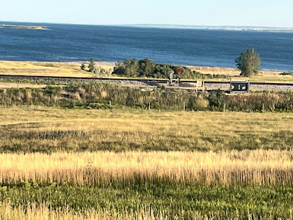
Early on in my ride today, I came upon the scene captured in the above photo. At first I found it quite confusing. What do you think? My answer can be found at the end of this post.
The dam is called a rolled earth dam, and is the second largest dam of its kind in the world. Not sure about what a rolled earth dam is, and of course I couldn’t ask that question either. Proceeding generally northward along the lake, I came across some huge fields of sunflowers and wheat. I took a picture of a large farm machine harvesting the wheat for a curling friend, Kyle, who is actually doing exactly that in Montana. Maybe Kyle and my paths will cross later on?
50 some miles later, I reach my destination for the day, Bob’s Resort. And to my relief, it was open. The owners have built a very good business here, which offers everything a tourist would be looking for. The complex includes a convenience store, campground, steakhouse restaurant and motel. Maybe not that amazing, but amazing considering my experiences on this vacation. I spoke with one of the owners, and he said they’ve been doing a good business considering the virus situation. I imagine their major clientele are fishermen. Of course, I had supper at the steak house. Best steak I’ve had in years, and huge. Breakfast the next morning- you’ve got it, leftovers warmed up in the microwave. Steak for breakfast. Mmm. What a difference one week makes!
So about that picture. Maybe not so obvious in the picture, but in reality it is obvious to any viewer that the two bodies of water are on different levels. But how can that be?
The green band of land between the two bodies of water is a huge embankment, and is actually the dam. It is the front side of the dam; the backside off the dam is the picture with the rock pile. No water flows over the dam; there is a power company off to the right that is unseen, and apparently all of the flow of the water past the dam must flow in underground tubes, which provides the energy to generate electricity. So in the picture the body of water above is Lake Oahe, and the water below is the Missouri River flowing toward Pierre.
Miles: 56
North progress: 44.2 miles. West progress: negative 4.5 miles (more on this tomorrow)
Elevations: Max: 1920. Min 1448
Max speed: 29.4 mph


This rock pile is actually part of the Oahe Dam.


Harvesting a wheat field.

View from my motel room at Bob’s Resort. US Highway 212 bridge over Lake Oahe.

very cool - Oahe...... looks complicated but so simple. Beautiful photos!!
ReplyDelete