Monday, August 21, 2023

August 11: Parshall and New Town

Van Hook Bay of Lake Sakakawea near New Town

A familiar foe showed up on day 4 - a tough headwind.  Generally, this year I found the cycling conditions easier than those I remember from 2020.  2020 featured never-ending heat and it seemed more than a fair share of headwind.  Thankfully, I was spared from the heat this year, but on my final ride for 2023, my route consisted of 7 miles north on 1804, and then a left turn and 17 more miles to the west on ND 23.  The weatherman predicted gusty winds of 20 mph out of the northwest. 

Just before the turn on ND 23, I rode through the town of Parshall, which is the home of the Paul Broste Rock Museum.  I was given a personal tour by the curator, who happens to be a little lady of 88 years.  Broste built the museum in 1964 and lived there for 8 years.  Then the museum was managed by his friend, a gentleman that was the husband of the curator.  Broste was a gentleman farmer, self educated, and a wizard at lapidary.  The museum was his life's dream work.    Most of the rocks displayed in the museum were picked up from the local area, although Broste traveled the world to pick up some of the specimens. He fashioned a machine which would cut and polish stones into perfect spheres.  I've never seen anything like this.  The photo below is the largest sphere he crafted and weighs in at over 300 pounds. Amazing and beautiful.  The museum houses around 680 of the spheres he made included in the imaginative displays.   This place was definitely worth the time.  The curator and her daughter are concerned about the future of the museum though, as they are not getting the needed financial support from the city.

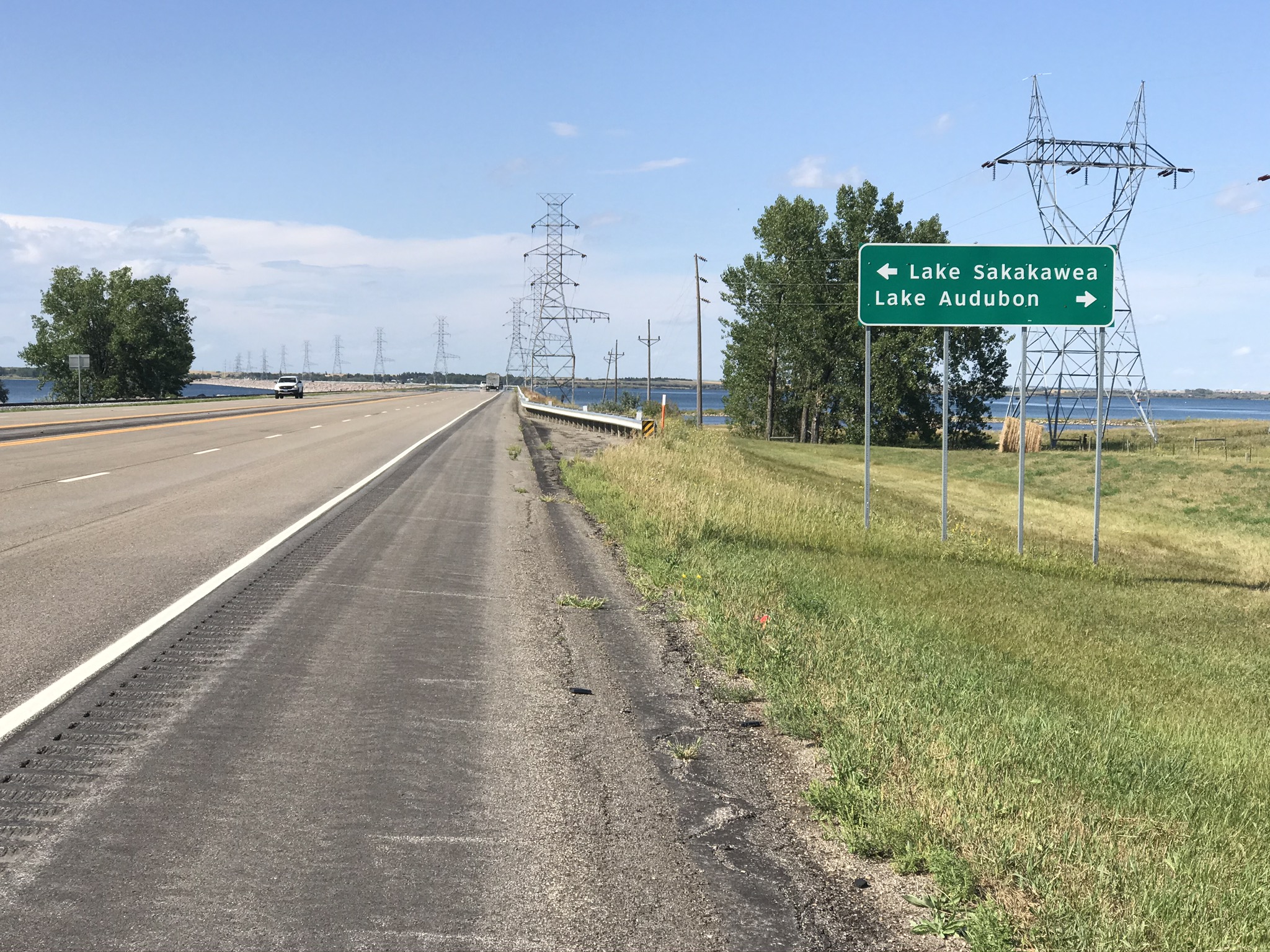
Returning to the bike, my final progress this year would be 17 tough miles along busy ND 23.  There were a fair number of oil wells along this route.  (As a matter of fact, Adventure Cycling, whose maps I've been using for the Lewis & Clark route, decided to alter the route  when the oil boom began in North Dakota.  The true Lewis & Clark route, which is highway 1804, was now considered to not be a suitable bicycle route, because of heavy truck traffic connected to the oil boom.  The new route travels some 100 miles south toward Dickinson.  However, I decided to remain true to the original route, and  take on the trucks and oil wells.  Had I taken the southern route, I would have not seen much at all of Lake Sakakawea, and not returned to the river until deep into Montana.)  ND 23 offered wide open views; one was over 8 miles.  The wind was tough, and the final 6 miles had a lot of road construction.   The road construction did make for some dangerous areas, and I was very careful to stay away from the traffic lanes, as much as possible.  Finally I passed the Van Hook Bay, which is the widest area of Lake Sakakawea, over 10 miles wide here.  The final miles of the route provided the nicest views of the Lake for this year.  Finally I passed the New Town sign which provides the finish line for this year!

Summary:

Distance: 49 Miles
Forward Progress: 24 miles
Time: 5:28.54
Max Speed 27.5 mph
Ave. speed: 8.8 mph
Lowest elevation:  1884  (only 24 feet above lake level).

Final summary for 2023:  4 days of travel:  175 miles. Forward Progress:  82 miles.

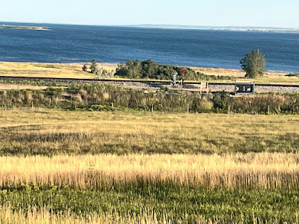
A very short train showed up at an opportune time - Van Hook Bay

A windy look down the road; 8 mile view to the west

A 300 pound perfect sphere of granite gneiss

Oil wells along ND 23.


Finish line for 2023!


Tuesday, August 15, 2023

August 10, 2023: Swimming Again


 Some vivid cloud colors before sunset

After a fairly long riding day yesterday (58 miles) I was interested in an easy riding day today.  While most of my riding miles lately have been westerly, today my entire forward progress was in a northerly direction.  I decided to ride for 10miles and then return to the truck.  I've learned that rest days are just as important as hard training days, especially as I have grown older.  I'm really pleased at how well the legs and knees have  handled the bike training.  In three weeks I plan to be on the ice curling.

I returned to the truck, and along the way passed a sign that indicated that it was just one mile from that point to a boat landing.  So from the sign, I headed in the indicated direction, and came across two more signs pointing in differing directions, but both directing travel to the boat landing.   Actually two different boat landings.  I followed one of the signs, and 3.5 miles later finally came upon a  boat landing.  The place was deserted; however there were two  unoccupied cars with boat trailers in the parking lot.  On the site, along with the boat landing, there was a dock which gave me a perfect opportunity to take a swim. The water was refreshing; not cold  but not warm either.   Clean and clear; very different from the muddy stream that pours into the Mississippi River.  Since this is a reservoir, there was no detectable current.  After a short swim, I quickly dripped dry in the dry North Dakota air.  It didn't take long, and I was back on the bike.  Most of the pictures below were taken on that short stint toward the boat landing.  As for route 1804, it is always nearby Lake Sakakawea, but not exactly next to the lakeshore. 


Descending to the Lake


a rain shower nearby


Sunflowers along the edge of the road.

Total Miles: 27.3
Forward Progress: 10 miles.
Average speed: 9.2 mph
Max speed: 23.8 mph
Max. Elevation:  2235 ft
Min. Elevation: 1953 ft.
Lake Elevation:  1860 ft.

Monday, August 14, 2023

Aug. 9, 2023: Mr. Basketball, 2021 North Dakota


Lake Sakakawea in the distance

Day 2 continues my bike ride this year along the Lewis & Clark  Expedition of 1804.  Fittingly, my route is along Highway 1804. The Missouri River in this area  (and for my enter ride this year) is named Lake Sakakawea, after the Indian maiden who accompanied Lewis & Clark and served as a scout and interpreter.  The Lake is a reservoir created by erection of the Garrison Dam, which was completed in 1956 by the Army Corps of Engineers.  The dam provides hydroelectric power and flood control for the Missouri River.  The dam is the largest of six dams on the river.  Lake  Sakakawea is the largest body of water entirely in North Dakota, and the third largest reservoir in the US.  It is 178 miles long.   Creation of the reservoir forced the displacement of two Native American villages and the communities of White Shield and New Town were created.  My route today went through White Shield, a community of about 200 souls.

Highway 1804 travels along the north shore of the lake, but does not get very near the shoreline in this area.  The photo above was my best view of the lake today.  Another photo shows a creek which winds its way toward Lake Sakakawea.  

The most interesting sight of the day was a sign showing Jesse White, a Native American who won the award of Mr. Basketball in 2021.  I found this to be quite inspirational!  White played at White Shield High School, a school with 39 students.  His height is listed at 5' 11", the only Mr. Basketball ever in North Dakota under 6 feet.  He ended up being the second highest scorer all time in North Dakota!  Most of the prior winners came from the larger cities in North Dakota, like Bismarck, Fargo, Dickinson, etc. which is what I would expect.  To win that award while playing at such a small school, another Hoosiers story, in real life.  White is attending the North Dakota State College of Science and playing basketball there.


Military cemetery at Grand Shield. All grave markers were identical, placed in perfect rows.


       White Shield is home of Jesse White, Mr. Basketball, 2021

        
                                           White Shield signs.                                         

A creek I crossed flowing toward Lake Sakakawea.

Distance:  57.5 miles
Forward Progress:  30 miles
Ave. 9.3 mph
Max. speed:  29.1 mph
Max. Elev.:   2213 feet
Min. Elev.:   1882  feet

Thursday, August 10, 2023

August 8, 2023: Three years later in Garrison, ND


Wally, the Walleye, at Garrison ND

So what am I doing in Garrison, ND?   Well, Garrison is the closest community to the point where I stopped my Lewis & Clark ride, three years ago.  This year I decided I would take up the ride again, albeit just for four days.  (I'm not riding on the Trans-Canada Trail this year, but decided I still want to do a bike vacation.)  So to bring us up to date, in  May, 1804 Lewis and Clark left from the mouth of the Missouri River (where it empties into the Mississippi, near St. Louis) on an expedition of the Louisiana Territory, commissioned by President Thomas Jefferson.  They traveled upstream until Oct. 29,  where they built winter quarters, and spent the winter.  The winter quarters were in this area, near what is now Garrison, ND.   At this point the Expedition took on a French fur trader named Touissant Charbonneau and his wife Sacagawea or Sacajawea or Sakakawea.  Historians disagree on the correct spelling.  Sakakawea turned out to be invaluable to the expedition as an interpreter to the Shoshone Indians  who lived in this area.  On  April 8, 1805 the expedition resumed travel up the Missouri River.  

My route this year continues my travel on North Dakota 1804, which is a rural highway which closely follows the Missouri River.  There are few towns along this route, which makes it a great route for biking, but tough for finding lodging.  I've decided to ditch the tent this year, in favor of staying at motels.  So my pack on the bike is lighter which I am enjoying, but that has created a situation for me which will greatly reduce the territory I am able to cover.  I discovered the next place for lodging beyond Garrison is at New Town, which is over 70 miles away.  No problem in my younger days, but no way did I want to tackle that on the first riding day, especially having done minimal bike training this year!  Yes, there was a resort and a bed-and-breakfast, but they were both booked solid. My only resort that I could think of, is to bring the pickup truck along, as I travel my route on bike.  Which means, ride some miles, then at the end of the day, return to the truck.  Move the truck to the starting point on the second day,  ride miles, return to the truck.  Essentially  I have to ride a round trip every day which cuts in half the distance I can cover reach day.

But Lewis & Clark ran into difficulties that slowed them down and some days they made very little progress.  So like them, I will have very slow progress this year.

I planned to start with an easier day to let the legs get accustomed to the work.  I covered 41 miles, not bad.  But the forward progress along the route is only 18 miles.  And while I have been always referring to the Missouri River as the route, due to a dam built by the US Army Corps of Engineers,  the river is now a huge reservoir, and the name is Lake Sakakawea.  More on Lake Sakakawea tomorrow.


View eastward along the route.  Lots of wheat fields.
One lonely tree, this ain't Wisconsin.

The sight of an abandoned coal mine.  I found a geocache here.

Lawn decoration, cowboy style.


The exact starting point of the route, at intersection of US 83 and ND 37/1804.

Total:  41 miles
Forward Progress:  18 miles
Minimum Elevation: 1877 ft.
Maximum Elevation: 2062 ft.


Wednesday, August 9, 2023

Confluence - Where this Journey Began!


July 30, 2023

All of the photos on previous pages of this blog were taken three years ago in the Covid year of 2020 when I took on this tour of the Lewis & Clark Expedition.  My friend's son Mason plays on a U16 traveling baseball team and this year his final tournament was held in the St. Louis area.  This gave me the opportunity to snap the photo above, at the place I could not get to back in 2020. The photo looks in a northeast direction.  On the left side of the picture is the Missouri River and the land on the other side  (it's not an island) is still in Missouri. Then immediately to the right of that land is where the Mississippi comes in, and the much further shoreline is the other side of the Mississippi, which is then the state of Illinois.

The story:  Three years ago, as I was about to set out on this bike journey, naturally I wanted a photo at the spot of the beginning of the Lewis & Clark Expedition, the confluence of the Missouri and Mississippi Rivers.  But I was stymied, due to Covid.  On the Missouri side the confluence area is in the Columbia Bottom park.  This was closed due to Covid, and the edge of the park is about 5 miles from the confluence.  I could've chanced it back then and just ride into the park, but it was going to be at least an hour excursion, and I didn't want trouble. 

Now to this year, the park is open, but is not well maintained.  The Visitor Center is closed and almost completely taken over by weeds on the outside.  There were several trails and roads to the confluence when this park was developed.  Only 1 of them remains open now.  A couple wrong turns at first, but finally I found the correct route, but still I encountered a closed road, now one mile away from the confluence.  A park person was posting signs for a lost dog, and I asked her if I could get to the confluence.  She didn't know!  

Not to be deterred now, I was riding my fat tire bike, which was perfect for the rest of the ride.  I went around that closed road sign, determined to walk, if needed.  It wasn't necessary; one mile later I arrived at the confluence! There was a nice observation point which contained concrete benches containing quotes.  My GPS device indicates an altitude of 429 feet, which is about 30 feet above the river.

After I left the confluence area, I followed a sign for a boat landing, and a  couple miles later arrived there.  The boat landing gave me a chance to get the iconic picture of my bike in the water at the start of the  L&C journey.  The GPS read 404 feet altitude here, which of course, is the lowest point of the entire ride, until the Expedition crosses the Rocky Mountains, and heads toward the Pacific Ocean on the Columbia River in Oregon.

Finally, taking leave of the boat landing, the return trip would be about 10 miles.  But only one mile as the crow flies.  Fat tire  bike to the rescue again, as I was able to find an overgrown path, and with the GPS device, was able to take the shortcut back to the Visitor Center.

Back in 2020, I tried one other method to get the confluence picture, that from the top of an observation tower in Illinois on the east side of the Mississippi.  That also was not open, but this year my sister and I toured the Tower.  As a thunderstorm was surrounding the area, we were able to get a couple photos from the top of the tower, showing the confluence from  a couple miles away.


This map is a nice depiction of the rivers in the area where they meet.  Both of them are flowing generally easterly in this area, and then after the confluence the combined river flows south toward St. Louis.  The Mississippi comes in on the upper left, the Missouri on the lower left.  The combined river leaves the map on the lower right.

                                            Columbia Bottom Park in Missouri.

                                             The view east from the confluence observation point. The rivers have just combined together.  The white structure on the opposite side is the Observation Tower in Illinois.
                                            Concrete benches at observation point. 


GPS device shows the confluence
                                            This pole indicates the heights of the top four floods.                                           


                                                      One more mile to go!


                             At the boat landing area.  I walked into the river, it was bathwater warm.


Observation Tower in Illinois.  The highest level is 150 feet above.

Looking to the west this is the view from the top of the observation tower.


Wednesday, July 6, 2022

Lewis and Clark Trip - Year One: Postscript


The Day I Met  My Guardian Angel


One orange, one apple and one banana

July 6, 2022

I've been waiting for this day, in order to wrap up and put a bow on my recount of the 2020 Bike Trip along the Lewis & Clark Bike Trail along the Missouri River.  This is the perfect date for this final story from that hot summer of 2020. 

Before leaving, I had made a conscious decision to try to find nutritious food selections, in the many gas stations and convenience stores I would come across along the way.  Many places don't stock fresh fruit;  Qwik Trips are great though,  and my goal was to eat one orange, apple and banana every day.  Truth be told, I didn't always achieve that goal, but it was on my mind every day. 

Now, I wish to suggest readers review my post for July 28, 2020.  Perhaps the toughest day of the entire trek, I was traveling with very little food and water, because nothing had been available  at Snake Creek Campground,  in South Dakota, where I had spent the previous evening.  Another instance of "closed on Mondays".   

It was a blistering hot day on Tuesday when  I had came across a small sign for Prairie Skies Country Inn.  While several miles off route, the sign had a phone number, and I was hoping against hope that my phone call would  be answered.   My intention was to ride there if it was really in business.  (Remember Covid).  Tom, the proprietor took my call, and proceeded to put together some food, jumped into his pickup truck, and met me along the way.   He came with food items for lunch - sandwiches, fruit and water.

While I was consuming his food, Tom proceeded to tell me the story of his daughter, who had taken seriously ill on a Catholic Church choir trip to Wisconsin, of all places a couple years earlier.  She had been mis-diagnosed in Wisconsin, and valuable time had been lost.  The Drs. did not have a favorable outlook about her  survival.  Then a miracle occurred.

 Maria Goretti was a young Italian girl who died at the age of 11 from injuries she suffered when she was stabbed 14 times.  On her deathbed she forgave her attacker.  The date was 1902.  She was canonized in 1950, one of the youngest saints of the Catholic Church.  The Church has set aside July 6  every year as her feast day. 

St. Maria Goretti was always  a favorite for Tom's daughter, and after a long period of  being bedridden on July 6 she began to recover.  Drs. have no medical explanation other than to say her recovery  was a miracle. She lost both legs to the terrible disease, but  now lives at home and has a strong will for life.  Tom recognized my predicament as an opportunity to Pay It Forward, for the miracle that had saved his daughter.

Tom seemed to have an intuition about the food items I would need that day, in order to continue my ride.  Along with the sandwiches he had packed in his plastic bag of food  there was exactly one orange, one apple and one banana.


Friday, April 23, 2021

August 14: Amtrak: A Train to Catch


Friday evening: Man’s work for the week is over, but God’s work continues unabated.

One final day on the bike, as I take leave of my constant companion, the Missouri River, and ride to Minot where I will catch The Empire Builder, for the trip home. This day was remarkable in several ways, in addition to being the last biking day ( I am not counting the ride home from the train station in Columbus, although it turns out that ride exceeded 30 miles.)  I have a good lighting system on my bike, but I found myself riding the bike after sunset only twice during the vacation. This was one of those nights.  The other night ride was to Higginsville, MO. This ride also was the longest for any day of the trip, coming in at 69 miles.  That beat the old record of 64 miles on my travel day in Missouri to St. Charles from Louisiana along the Mississippi River. 

I can truly say that some of the riding days I put in at the end of the trip, I could not have completed at the beginning.  I don’t think I could’ve handled that headwind on the ride to Bismarck, had that been my challenge at the beginning of the ride.  Or let’s say that I wouldn’t have been able to jump on the bike the next day, with fresh legs.  And certainly I became somewhat acclimated to the heat over the summer, as I found myself riding on 90 degree days.  So it was fun to see my fitness improve at least a little bit. 

The scenery highlight of the day was Lake Sakakawea. Named after the Indian maiden who joined the Expedition, most of the rest of the country call her Sacajawea or Sakagawea.  Actually this is the a area where she lived, and returned to,  after the Expedition.  Lake Sakakawea, like all of the their large bodies of water in the Dakotas, is man made,  as the Missouri is backed up by the Garrison Dam. Highway 83 creates a causeway between two bodies of water, which is a couple miles long.  Certainly one of the scenic highlights of the trip! My favorite picture of all of the Missouri River pictures is the last one, which shows the lake shimmering in the late afternoon sun.  If I decide to continue the ride sometime later, this will be my starting point, a point over 1300 miles from the start of my ride at St. Louis.

So after I take leave of Big Mo (anybody remember Mobridge?), I have about a 40 mile ride to Minot, right along the shoulder of good old US 83. Along this final stretch of the trip, I achieved a new max elevation of 2243 feet, so I guess I can say I left the trip on a high note!  I snapped the photo at the top of this posting, as the sun was sinking on this, a Friday night.  Too bad I didn’t think to make this photo a video, it would have made my point more plainly. A metaphor perhaps of my journey, a video would have shown the machines to be at rest, and the windmill still churning, on the left horizon. 

So for folks following along on my journey, I plan one more posting to the journal after this one, to summarize, and wrap it all up with some final thoughts.


Miles:  69
 Elevations: High 2243  Low 1718
Max Speed. 22.7 mph


                                                     Lakes Audubon and Sakakawea

               Highway 83 forms a causeway between the two lakes. Sakakawea to the left.
                     Lake Sakakawea: To think this is the same body of water called the Big Muddy

                          My final and favorite snapshot of the Missouri River (Lake Sakakawea)

I’m getting close  to Canada now!


August 11: Parshall and New Town

Van Hook Bay of Lake Sakakawea near New Town A familiar foe showed up on day 4 - a tough headwind.  Generally, this year I found the cycling...