
All of the photos on previous pages of this blog were taken three years ago in the Covid year of 2020 when I took on this tour of the Lewis & Clark Expedition. My friend's son Mason plays on a U16 traveling baseball team and this year his final tournament was held in the St. Louis area. This gave me the opportunity to snap the photo above, at the place I could not get to back in 2020. The photo looks in a northeast direction. On the left side of the picture is the Missouri River and the land on the other side (it's not an island) is still in Missouri. Then immediately to the right of that land is where the Mississippi comes in, and the much further shoreline is the other side of the Mississippi, which is then the state of Illinois.
The story: Three years ago, as I was about to set out on this bike journey, naturally I wanted a photo at the spot of the beginning of the Lewis & Clark Expedition, the confluence of the Missouri and Mississippi Rivers. But I was stymied, due to Covid. On the Missouri side the confluence area is in the Columbia Bottom park. This was closed due to Covid, and the edge of the park is about 5 miles from the confluence. I could've chanced it back then and just ride into the park, but it was going to be at least an hour excursion, and I didn't want trouble.
Now to this year, the park is open, but is not well maintained. The Visitor Center is closed and almost completely taken over by weeds on the outside. There were several trails and roads to the confluence when this park was developed. Only 1 of them remains open now. A couple wrong turns at first, but finally I found the correct route, but still I encountered a closed road, now one mile away from the confluence. A park person was posting signs for a lost dog, and I asked her if I could get to the confluence. She didn't know!
Not to be deterred now, I was riding my fat tire bike, which was perfect for the rest of the ride. I went around that closed road sign, determined to walk, if needed. It wasn't necessary; one mile later I arrived at the confluence! There was a nice observation point which contained concrete benches containing quotes. My GPS device indicates an altitude of 429 feet, which is about 30 feet above the river.
After I left the confluence area, I followed a sign for a boat landing, and a couple miles later arrived there. The boat landing gave me a chance to get the iconic picture of my bike in the water at the start of the L&C journey. The GPS read 404 feet altitude here, which of course, is the lowest point of the entire ride, until the Expedition crosses the Rocky Mountains, and heads toward the Pacific Ocean on the Columbia River in Oregon.
Finally, taking leave of the boat landing, the return trip would be about 10 miles. But only one mile as the crow flies. Fat tire bike to the rescue again, as I was able to find an overgrown path, and with the GPS device, was able to take the shortcut back to the Visitor Center.
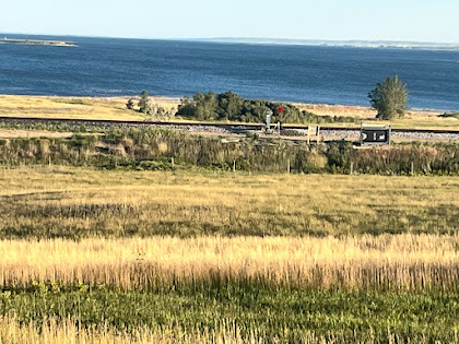
Back in 2020, I tried one other method to get the confluence picture, that from the top of an observation tower in Illinois on the east side of the Mississippi. That also was not open, but this year my sister and I toured the Tower. As a thunderstorm was surrounding the area, we were able to get a couple photos from the top of the tower, showing the confluence from a couple miles away.

This map is a nice depiction of the rivers in the area where they meet. Both of them are flowing generally easterly in this area, and then after the confluence the combined river flows south toward St. Louis. The Mississippi comes in on the upper left, the Missouri on the lower left. The combined river leaves the map on the lower right.


No comments:
Post a Comment