Tuesday, September 8, 2020

August 13: Washburn, ND. Journey’s End


                                1804 and 2020:  Winter Layover at Fort Mandan, near Washburn ND  


Upon arriving in North Dakota, I made the decision to bring my bicycle journey to an end for 2020. When I made the decision, I arrived at the decision quite abruptly. Meaning the day before, I was still harboring the notion of completing the entire journey this year. There were several factors that influenced my decision. One primary  reason was the remoteness of the territory I would be traveling through.  Had I continued on. ND 1804, I would be traveling for two full days, without a single town, gas station, restaurant, etc. until arriving in Bismarck.  The trail swings westward at this point, and travelers along I-94 will recall that the most frequently seen sign on the exits in ND, is ‘No Services’.  Stocking up with two days or more of water and food on the bike, was not something I would look forward to doing.  The ever present possibility of a bike breakdown also was a consideration.  I was starting to think about the financial cost of the trip also.  The cost of sleeping in motels for another two months, would be considerable.  

One day (on the bike) north of Bismarck along the Missouri River, was the location at which Lewis & Clark decided to build a a fort . At this point L&C decided to stop for the winter, and so shall I. 

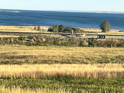
Departing from Bismarck I made a short stop at Hawktree Golf Club.  It’s a fairly new course which I remembered visiting while curling once in Bismarck.  It is rated no.19 among best public courses by Golf Digest. The thought crossed my mind to play 9 holes but it wouldn’t have worked out for an arrival at Washburn, the only town along the route today. Truth be told, this corse is too difficult for me also.

It turned out to be another very warm day, and during the mid afternoon, I saw an opportunity to carry through on a goal I had since the beginning of the trip - a swim in the Missouri. For much of the trip, the river looked like a mud puddle.  Here in ND, the waters looked nice clear blue reflecting the skies. A couple of reflections: the water temp was pleasant, similar to an outdoor pool in the summer. The current was very strong, I certainly could not outswim it. And, I stayed near the shoreline.  I’m sure the current was even stronger in the main channel.  And the river is still a very large one, here 1300 miles from the mouth. Several times the size of the Wisconsin River. This just gave me a still greater appreciation of the achievements of L&C, towing boats upstream.  I jumped in while wearing my shorts and shoes. It took very little time for these to dry out later when back on the bike, low humidity in ND.

Finally, by late afternoon, I arrived at Washburn, which is the closest town to Fort Mandan, the winter quarters for L&C.  One more El Cheapo motel, located on the town’s Main Street for me. This motel, which is more commonly used for extended time  clientele, was converted from a clinic and hospital. I was the only resident for the night. In order to get the AC turned on in the first room they gave me, the motel caretaker had to call the owner.  She used a broom stick to open up the register located above the door to the room.  They eventually gave up and put me in a huge double room that had better AC:

Miles: 45.3 
Average 6.8 mph - another headwind for the whole day
Elevations: High 1891. Low 1643
Max speed: 23 mph
 

            View of a green on Hawktree Golf Club, rated  19th best public golf course in the US

                                              Accommodations in Washburn were interesting!

                                                             River view from ND 1804
                                                       View of 18th fairway at Hawktree


                                                        River elevation now is 1649 ft

                                Taking a break from the bike on yet another 90 degree day

Friday, September 4, 2020

Aug. 12: Bismarck sightseeing and Math Q4


                               North Dakota Capitol Building - 19 floors. From the top, see 30 miles?

I stopped at a My Place hotel, a newish chain of motels.  Very nice but less expensive than some of the other motel chains. I decided to stay in Bismarck a few days, and made my reservation on Amtrak from Minot for my trip home.   Sure enough, wouldn’t you know it, the wind shifted on the next day and that headwind into Bismarck would’ve been a tailwind. I guess I just got to Bismarck one day early.

I took a self guided tour of the Capitol Building. As you can see, it doesn’t look like a Capitol. It looks more like a skyscraper. The story is that the original Capitol Building burned back in the 1930’s. When they decided to rebuild, they wanted to build a structure that made efficient use of the space, and they decided a skyscraper office type building was most economical. Inside the building, you miss the central rotunda upward view provided by the. Capitols in Madison and Jefferson City.   However, the main floor is still built in a very grand manner and features a 40 foot ceiling and some massive interior pillars. Floor 18 is reserved as an observation deck, so I was eager to check that out. While the door to the outside was locked, I still got some impressive views from inside.   The  observation deck provides the backdrop for Math Q4, so math fans should check that out below.

While in Bismarck, I also checked out the North Dakota Railroad Museum. On my first day there, I got to talking with the  guy who was managing the museum. Small world moment - the manager used to live in Madison, and I would pass right next to his residence on days when I would ride my bike to work from McFarland.  Amazing how often that sort of thing happens while on a vacation.  I spent so much time in conversation with the friendly guy that I didn’t get to see all of the exhibits and items on display. I returned the following day to see what I had missed.

All in all I spent three enjoyable days in Bismarck before returning to the Lewis & Clark expedition trail.  

Now to some math!  For the answer to Math. Q3, check out the solution at the bottom of this post.  Finally, one more math problem, Q4. The literature at the North Dakota Capitol boasts that on a clear day you can see  from 30 - 35 miles from the observation deck on top of the building. It also says that the building is 240 feet tall.  How accurate is that statement about seeing at least 30 miles?


Miles:  75  (these miles accumulated while riding around the city, and do not count in my distance traveled from the end of the river by St. Louis)

                                    Coast Guard emblem decorates bridge over the Missouri River

                             Southerly view from observation deck on the 18th floor of the Capitol

                                                 Northerly view from same observation deck.


                                                      State Capitol interior view. 40 foot ceiling


                                                              State Capitol interior view. 


 Solution to math  Q3

The question is to determine how many miles in a degree of longitude, for an observer at 45 degrees. North Latitude. This problem is more difficult than Q2, which dealt with the mileage in a degree of latitude.  In the diagram above, we are interested in the circumference of circle BGDF which has its center at point C.  Notice from the diagram the position of angle CBO which is congruent to angle AOB.  Angle AOB is  equal to the latitude measure, hence 45 degrees. Segment OB is a radius of the earth, so we consider that is 25,000 divided by 2pi which works out to about 3979 miles.  This is really close to 4000 miles so that is what I use in the diagram above.  Finally segment BC is  equal to segment OB multiplied by the cosine of 45 degrees.  My calculator shows the cosine of 45 Degrees is about .7071. Then  AO is 2828 miles and the circumference of circle BGDF is  2828 x 2 x pi = 17,772 miles. Finally we are at the point where this problem is similar to Q2.  The circumference of 17,772 corresponds to 360 degrees so each degree is 17,772 / 360 =  49.4 miles.

Additional Comments: My ‘rule of thumb’ for latitude and longitude:

When I am riding my bike, I am always looking at my GPS device which measures latitude and longitude not only in degrees but also in minutes of  latitude/longitude.  There are 60 minutes in each degree, so I divide the results  for Q2 and  Q3 by 60 and I talk about miles per minute of angle measure.  So for Q2, I come up with  69.4/60  =  1.16 miles per minute of latitude, which is very close to 7/6 of a mile.  For longitude I get  49.4/60 = .82 miles per minute.  But 45 degrees is quite a northerly position to measure the latitude - it corresponds to central Wisconsin, and of course most of the country is south of that, and so most of the country has more than .82 miles per minute.  .85 miles per minute of longitude seems to be a reasonable estimate for longitude, and that works out to 6/7 of a mile. So my rule of thumb is: a minute of latitude is 7/6 of a mile and a minute of longitude is 6/7 of a mile.

Finally, one more observation!  On my vacation, my most southerly point (Jefferson City) was 38.5 degrees latitude. A degree of longitude at Jefferson City is about 54 miles. My most northerly point of the trip is Minot, ND at 48 degrees latitude, and the length of a degree of longitude there is 46 miles, which means a difference of 8 miles compared to Jefferson City. That fact rather blows me away. I would never have estimated that difference to be that large, on my little bike trip, compared to the size of the earth!

August 11: Parshall and New Town

Van Hook Bay of Lake Sakakawea near New Town A familiar foe showed up on day 4 - a tough headwind.  Generally, this year I found the cycling...